We perceive river divides, which form the boundaries between catchment areas, as stable features of the landscape. However, over time scales ranging from thousands to millions of years, these divides are subject to significant changes. These changes can occur through the slow migration of the watershed or through a sudden shift known as river piracy, reflecting the overall dynamics of landscape development driven by geological or climatic processes.
If we let our imaginations run wild for a moment, we can view watersheds as a space where watercourses engage in a relentless struggle for territory.
- Can we identify the locations of the most significant watershed shifts and predict future developments?
- Can we identify the causes of this migration?
- Why do some segments of the watershed migrate dynamically whilst others remain relatively stable?
Our colleagues Roberta Prokešová and Ján Novotný posed similar questions in an article published in the journal Geomorphology.
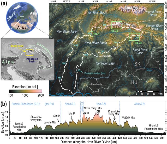
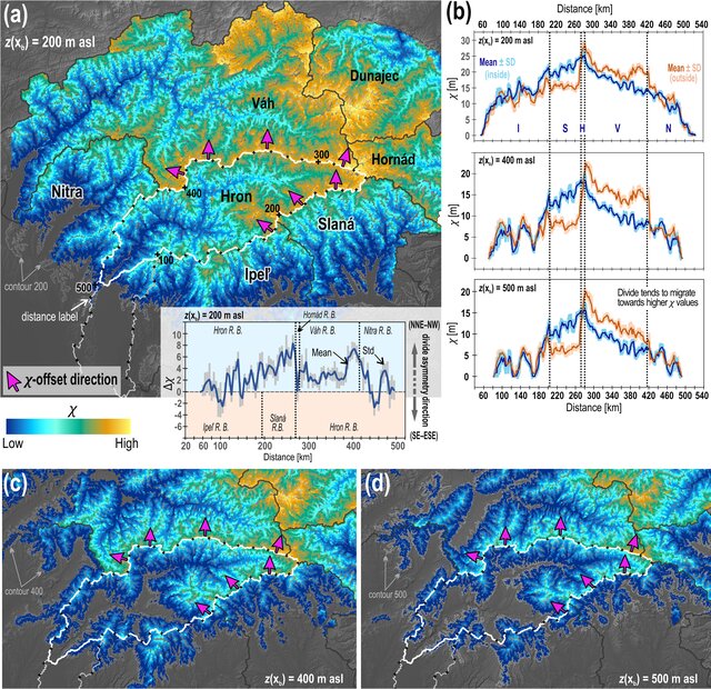
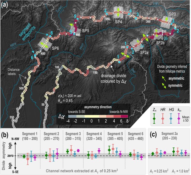
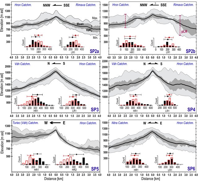
They focused their research on one of Slovakia’s best-known rivers – the Hron – and its main watershed. The study is based on an analysis of digital elevation model (DEM) data and the quantitative topographic parameters (known as metrics or indices) extracted from it. The degree of asymmetry in the values of these parameters, identified using statistical methods, highlights differences in the intensity of erosion processes on opposite sides of the watershed. The differing intensity of erosion is the main direct cause of watershed instability; however, it reflects the influence of a whole range of factors and processes, from regional ones—mostly tectonic—to local or short-term (in geological time scales) ones. The combination of two categories of metrics – fluvial and slope-related – confirmed the assumption that each category of metrics is sensitive to factors operating at different spatial and temporal scales. Fluvial metrics such as the χ (chi) index or the ksn steepness index indicate a relatively uniform trend of watershed migration towards the north in response to the main regional factor – the ongoing tectonic uplift of the Western Carpathians, which remains active although its intensity is currently only moderate. Conversely, the values of slope (so-called Gilbert) metrics, which characterise the topography of slopes adjacent to the watersheds, show a lower degree of asymmetry, indicating greater stability of the analysed watersheds. This apparent discrepancy may have several causes, ranging from the oscillating nature of the tectonic uplift of the Western Carpathians, through the influence of local processes such as glacial erosion or landslide activity, to the stabilising effect of erosion-resistant rocks forming some of the watershed ridges.
The study thus provides answers to the interesting questions outlined in the introduction, whilst also raising new ones that require further research. It is therefore a fine example of how scientific research is an exciting journey, full of surprises, emerging questions and the search for answers to them.
Why this is important
- For understanding the Carpathians: topographic indices enable the identification of areas with distinct geomorphological processes.
- For methodology: combining river and slope indicators provides a more accurate context than using a single index.
Publication: Prokešová, R. – Novotný, J. (2026). Dynamics of the Hron River drainage divide (Western Carpathians): From regional drivers to local controls. Geomorphology, 493, 110077. IF 2025: 3.2; Q2 JCR.
Link: https://doi.org/10.1016/j.geomorph.2025.110077
This article forms part of research carried out as part of the project:
- VEGA 2/0014/25 — From Digital Topography and Geomorphometric Indices to Erosion and Uplift Rates
Prepared by: Ján Novotný, Róberta Prokešová | With the assistance of GPT-6 Astra.