PHYSICAL GEOGRAPHY, GEOECOLOGY AND GEOINFORMATICS
PhD topics focused on geomorphology, geoinformatics, remote sensing and environmental processes.
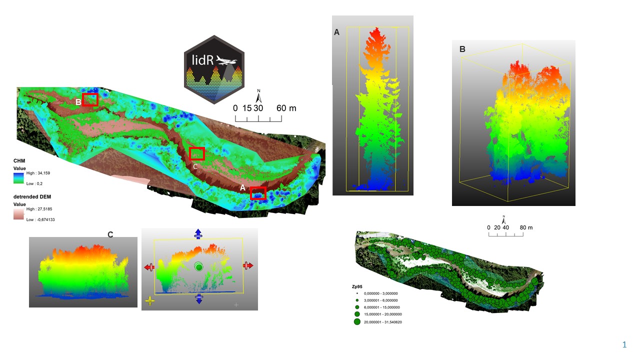
The aim is to classify the point cloud using machine learning and deep learning methods (AI) with a focus on vegetation. For vegetation detection, methods will be employed to directly classify point clouds from LiDAR in the Python programming language, utilising artificial intelligence techniques within the TensorFlow libraries (and others). Training and test regions will be manually selected from measured point clouds. The work focuses on woody vegetation in riparian zones of watercourses with various successional stages. A dynamic series of point cloud data will be used to understand the process of vegetation succession and to identify the spatiotemporal trajectories of vegetation at different successional stages (transition from succession to rejuvenation or stability). This PhD position presents a valuable opportunity to contribute to ongoing research projects.
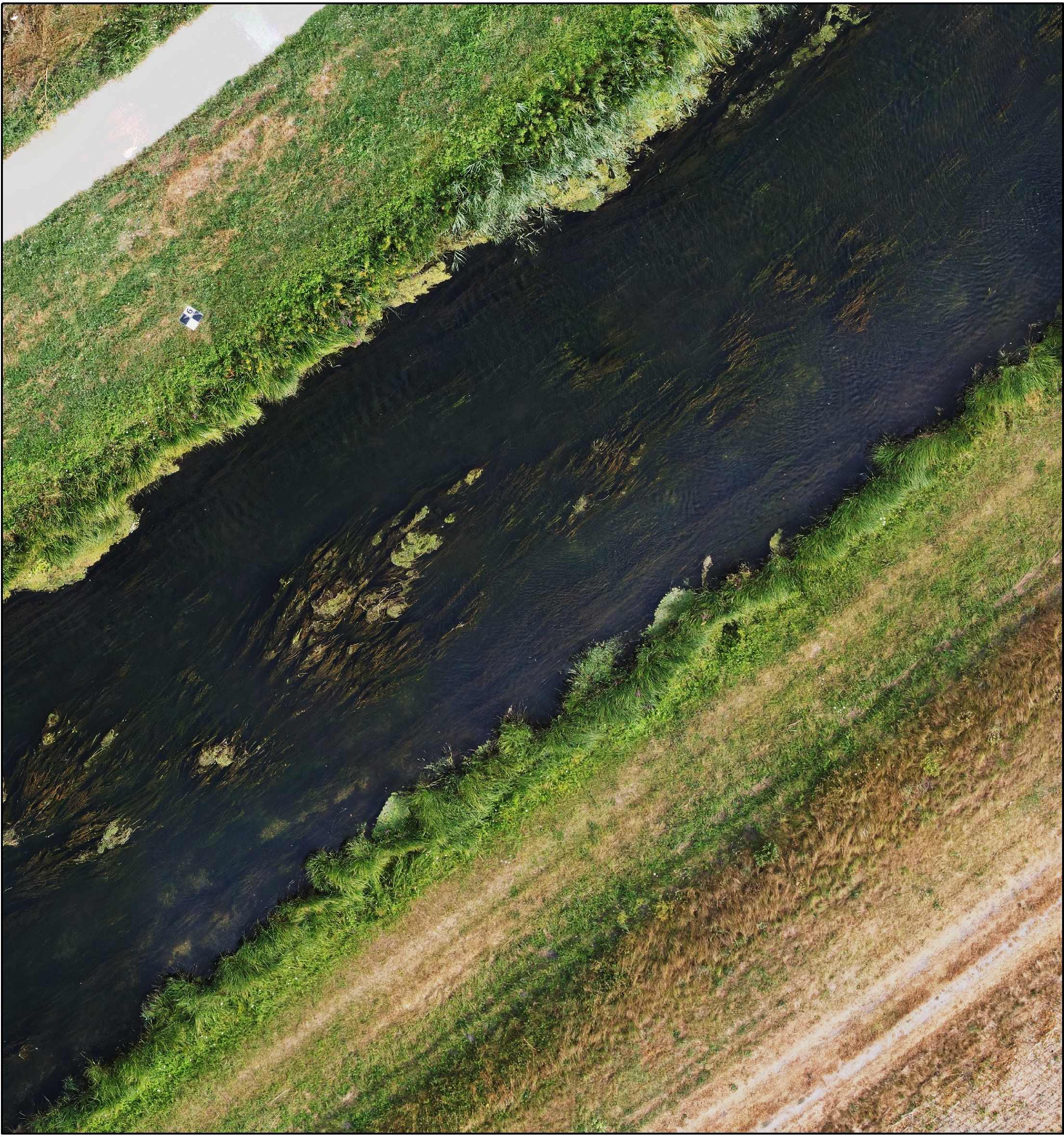
The aim of this work is to integrate the spectral characteristics and geometric properties of point clouds for assessing biodiversity and biomass in riparian zones. The work combines the use of satellite data with the mapping of selected river sections using a handheld lidar scanner. Based on a dense point cloud, a virtual reality of the current state will be created, showing rare and endangered ecosystems and wetlands. Individual models from terrestrial scanning will then be compared with one another in a time series and with optical satellite data. The volume of stored material and the grain size composition of sediments will be analysed based on the processing of dense point clouds and their geometric properties. The work focuses on collecting data in the field and processing point clouds to analyse the relationship between vegetation and morphological changes in the river channel. This doctoral position presents an excellent opportunity to contribute to ongoing research projects.
The aim of this work is to identify large wood and its interaction with morphological processes in the river channel, such as erosion and accumulation. The main aim is to investigate temporal variability in LW storage at the scale of individual meander bends, utilising a broad range of environmental and hydroclimatic settings. The behaviour and distribution of LW are primarily governed by river-specific factors. Riparian vegetation is a significant predictor of storage and input into the channel. The natural process of vegetation change in the riparian zone is then the result of succession and rejuvenation, which are linked to new and altered geomorphological forms. The work is based on the processing of 3D drone data, which will be used to identify processes and changes in the river landscape. This PhD position presents a valuable opportunity to contribute to ongoing research projects.
The aim of this work is to create and classify a complex 3D model of the channel bed by processing drone data using Structure from Motion (SfM) photogrammetry. The work focuses on detecting and reconstructing underwater vegetation, as well as identifying seasonal changes throughout the year. The work is based on model building using optical data obtained from drones and the automatic classification of different types of landforms based on cloud geometry. The results will be validated by a field survey. The physical parameters of the channel will be extracted from detailed 3D models, from which channel bathymetry will be calculated, channel bed structure, gravel bars, submerged vegetation and bed substrate below the water surface will be reconstructed, and individual habitats will subsequently be identified. This PhD position presents a valuable opportunity to contribute to ongoing research projects.
The loss of ecological connectivity in increasingly fragmented human-dominated landscapes threatens the long-term persistence of many species. The Northern Carpathians are a European hotspot of natural wildness harboring the umbrella species, e.g., brown bear or European bison. However, land-use changes such as infrastructure or settlement development, agricultural intensification, and forest harvesting put wildlife in the constant thread. This PhD aims to assess ecological connectivity and its changes based on GPS telemetry and remote sensing data. The successful candidate will integrate telemetry data for species movement, remote sensing imagery and stakeholder knowledge into a powerful, spatially explicit connectivity assessment. A successful candidate should be fluent in English and passionate about wildlife and remote sensing. This PhD position offers a great way to join international research projects. A good knowledge of the Slovak language is advantageous.
The dynamics of biotope structures often act as either a cause or a consequence of ecosystem changes. Detailed information about biotope changes is often missing, which limits our understanding of these ecosystems. This PhD thesis opens up the possibility to work with a large variety of remote sensing data (generated from ground-based sensors, aerial, or satellite imagery) to synthesize knowledge about biotope structures and their changes and link it with the changes of the ecosystems. This PhD position offers a great opportunity to join an international research project funded by Biodiversa+ that focuses on redesign of rural landscapes. Good knowledge of the Slovak language is advantageous.
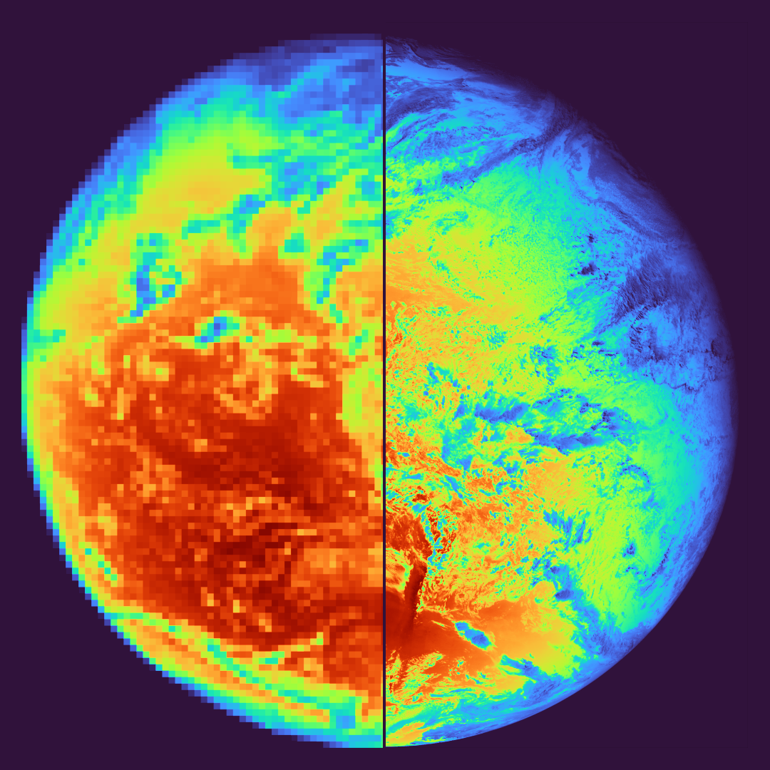
Models using geostationary satellite data to estimate surface solar radiation globally are instrumental to the wider adoption of solar electricity production and energy transition in general. The accuracy of such models, typically evaluated against point-based ground measurements, is a key property that has direct economic consequences for users of the data in the solar industry. With the advent of new generations of geostationary satellite instruments, the pixel size of visible spectrum images has gradually decreased from 3 km to 0.5 km while the temporal interval dropped from 30 to 5 minutes. Moreover, the pixel size is poised to halve in the next decade. This brings the spatial basis of the model closer to the one of measurements, potentially improving the fit. However, the increased resolution presents significantly higher computation and storage costs. There are additional challenges, such as the need for precise georeference, cloud parallax and shadow effects, and resolution differences between visible and infrared channels. The dissertation aims to analyse the feasibility, benefits and pitfalls of solar radiation modelling at 1 km and finer resolutions. The candidate gets an opportunity to collaborate with a major solar data and solutions provider Solargis s.r.o., and work with experts with extensive expertise in the field including utilisation of data and processing infrastructure.
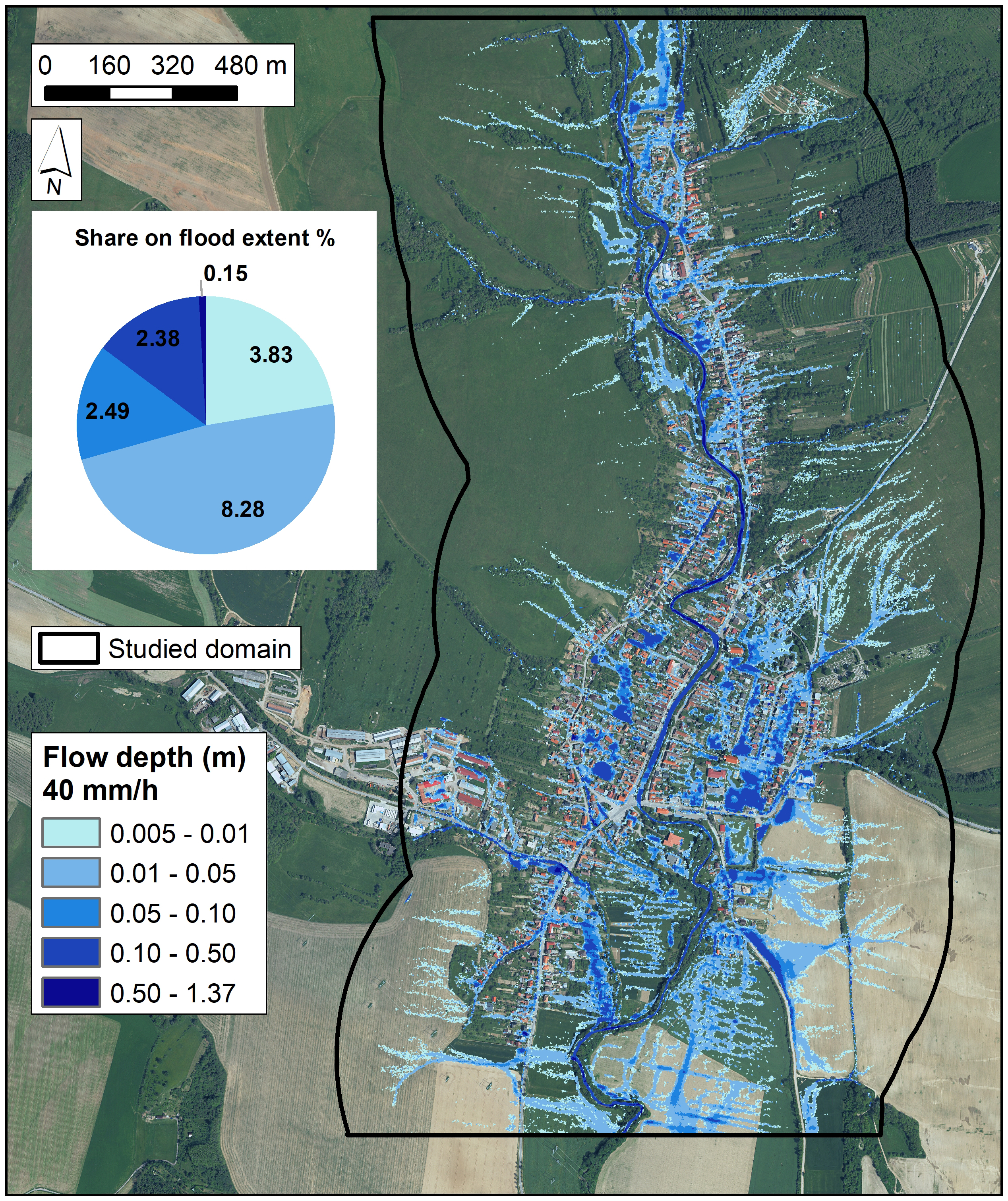
Flood hazard mapping primarily focuses on spatial representation of flood extent and flow depths. Although conventional physically-based models are highly accurate, their deployment for real-time flood mapping is limited due to high demands on data preparation and long computational times. Using the physically-informed data-driven, particularly machine and deep learning, approaches provides opportunities for fast inundation predictions as well as transferring the results to other unmapped areas. The aim of this dissertation thesis is to develop physically-informed machine and deep learning models to simulate the flood extent and flow depths based on high-resolution spatial data and data generated via the hydrologic-hydraulic models. The thesis aims to address the fluvial as well as pluvial flood types. The integration of rainfall-runoff, hydraulic, machine/deep learning, and geo-information technologies is anticipated in this dissertation thesis.
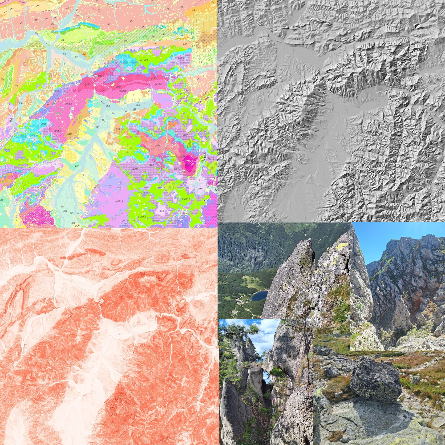
Landscape evolution is controlled not only by tectonic forcing and climatic fluctuations, but also by the spatial variability of rock erodibility, a complex characteristic integrating multiple physical and chemical factors of the rock environment. Direct laboratory quantification of erodibility is practically unfeasible over larger areas with heterogeneous lithology. Therefore, in tectonic and geomorphologically oriented studies, the intensity of erosional processes is commonly expressed using a set of gradient-based metrics extracted from digital elevation models, without the need for experimental determination of the material properties of the rocks themselves. This PhD project aims to evaluate, using spatial and statistical analyses, the sensitivity of selected gradient-based metrics to lithological contrasts in representative study areas. Particular emphasis will be placed on identifying threshold values that indicate non-linear landscape responses in the relationships between metric values and the intensity of relief-forming processes. The expected outcomes will contribute to an improved understanding of the controls on landscape morphology and to a more robust interpretation of morphometric indices in geomorphological research.
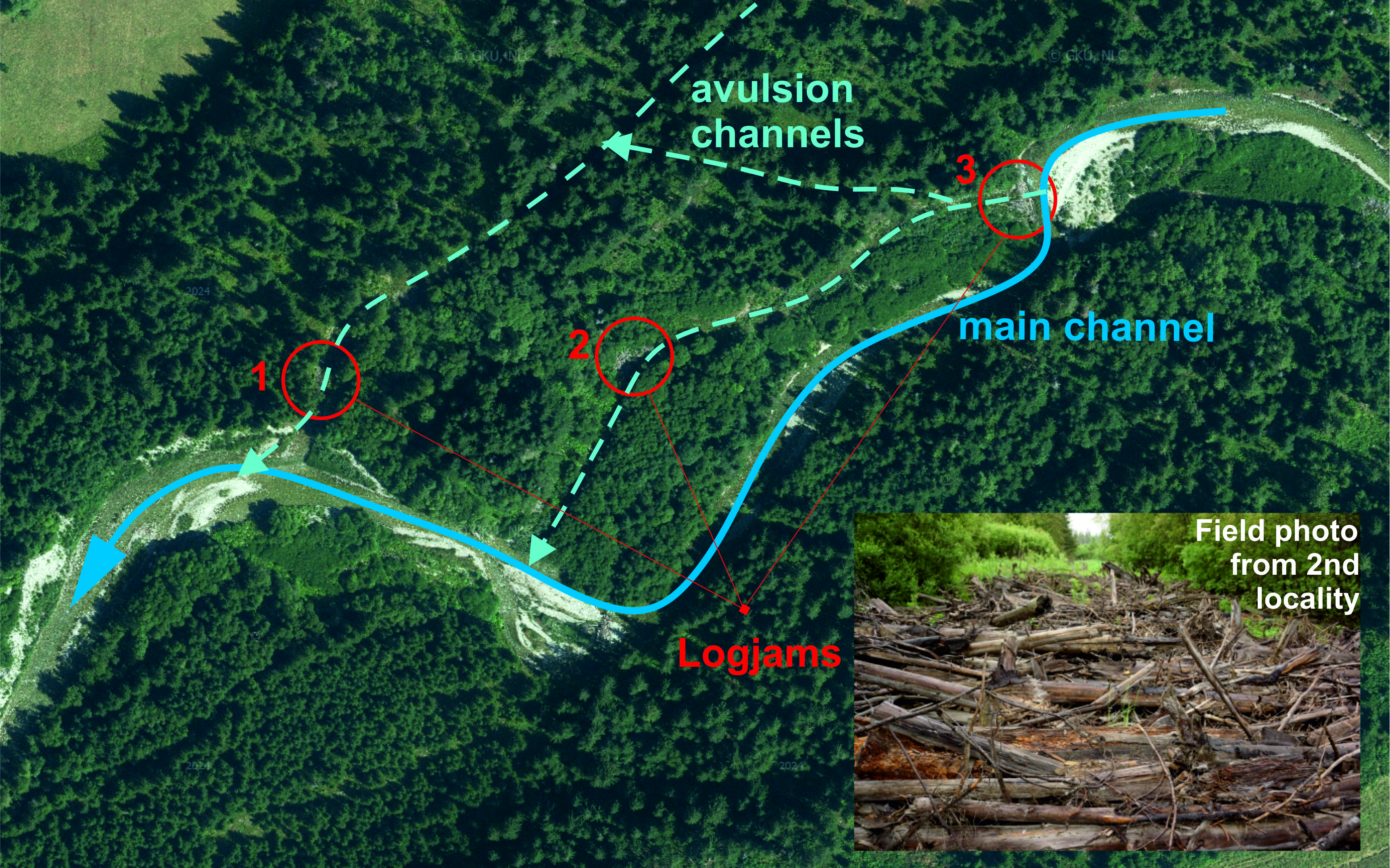
Large woody debris (LWD) significantly influences flow regime, channel morphology, and processes in gravel-bed rivers. Consequently, LWD plays a signigicant role in sediment transport and in-channel landforms formation. Especially logjams accumulation create conditions for channel planform adjustment and support channel narrowing, increase flow depths and pool frequency. PhD thesis will determine the geomorphic controls that influence logjam deposition. In addition, we will assess how geomorphic characteristics (e.g., valley confinement, slope) may influence logjam deposition on avulsion channels in comparision to clumps accumulation on main channel. Very recent hydrological data will provide analysis concerning to size and duration of the maximum discharges where the individual sequences of logjams accumulation were proven. The high-resolution LiDAR with combination of UAV data for volume calculation as well as the 3D model of logjams creation will be used.
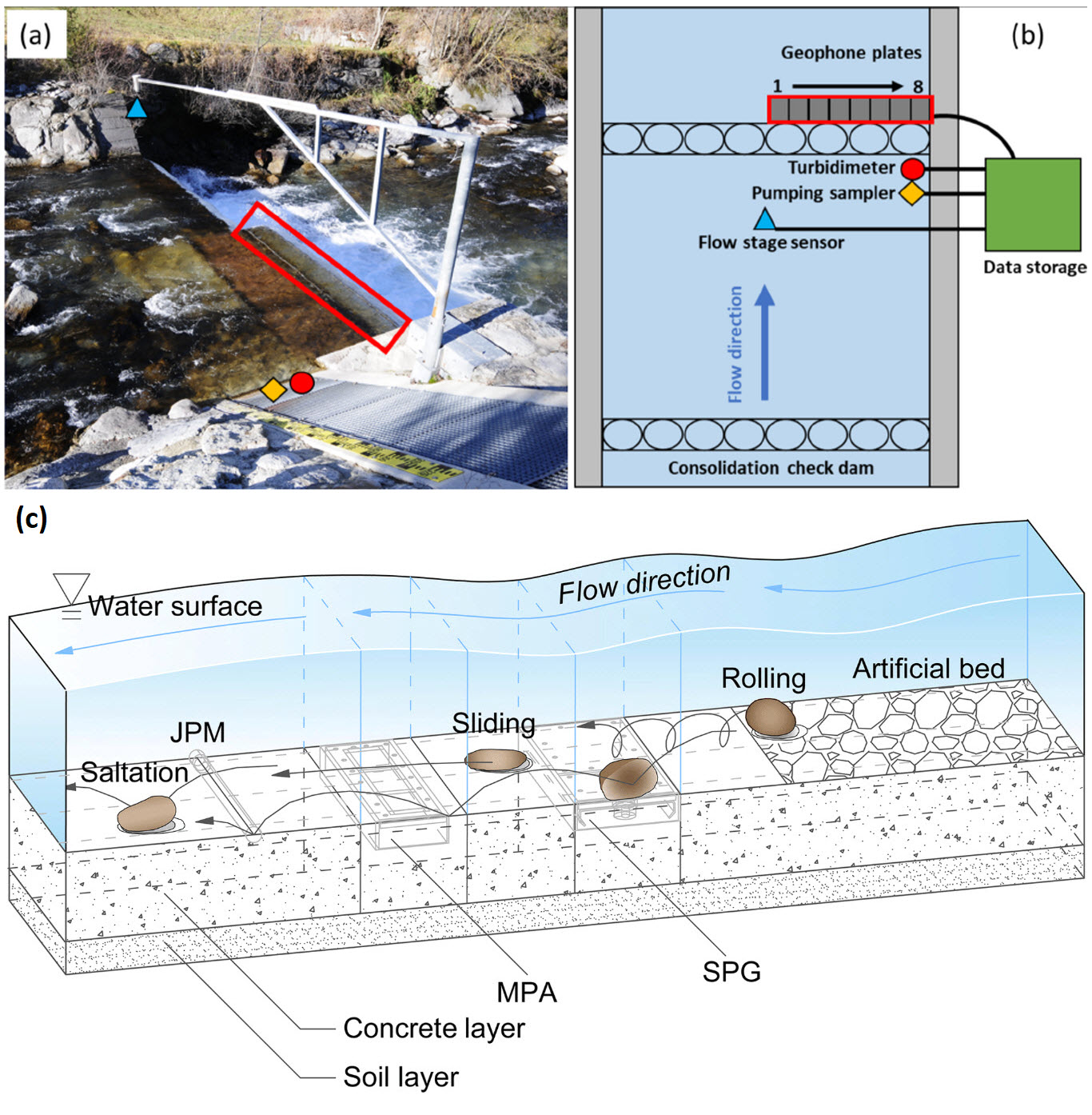
The aim of the dissertation work will be to analyse data obtained from a newly established monitoring station on the Belá River. The local hydrological-sedimentological monitoring system, based on the connection of a flowmeter, a suspended particle sensor and a geophone plate, can monitor the flow velocity and water level, the particle size of the suspended load and bedload transport. Typical glacifluvial clusters, characterised by a predominant granite, a potential source of sediments, are represented by a system of cut-bluffs formed by flysch, which is crushed into smaller particles during transport. The obtained data will be evaluated in relation to the hydrological regime affected by climate change and management strategies within the Natura 2000 protected area.
REGIONAL GEOGRAPHY
PhD topics focused on social, urban and regional processes.
Land use change is caused by multiple drivers acting on multiple scales. While some causes of land change may be identified on the local scale, others may act on the regional or continental level. Additionally, land change often results from teleconnections between distant socio-ecological systems. The aim of the thesis is to identify the drivers of land use change in a selected region of the world with particular attention to agricultural land systems.
Same as in past decades, the future landscape in Europe will be influenced by multiple drivers such as climate change, urbanization, demographic trends and technological development. The aim of this work is to develop scenarios of future land use and ecosystem services in Europe based on land cover data, environmental conditions and results from participatory workshops with stakeholders.
The thesis focuses on a comprehensive assessment of quality of life in the regions of Slovakia by combining objective indicators and subjective perceptions. The research will examine spatial disparities and factors influencing regional quality of life.