The Atlas “Ukraine. Cultural Landscape Heritage” is a comprehensive cartographic work designed to promote the protection, conservation, and management of Ukraine’s cultural and natural heritage. Featuring 39 interactive maps, the Atlas presents cultural landscapes at global, national, regional, and local levels.
Atlas ‘Ukraine. Cultural Landscape Heritage’ was created as one of the priority actions to accelerate the pace of practical implementation and popularisation of the cultural landscape approach to the protection, conservation, and management of the cultural and natural heritage in Ukraine.
The Atlas was developed to generate, structure, and visualise up-to-date spatial information and knowledge about the most significant part of the cultural landscape heritage of Ukraine and its regions, which is covered by the existing territorial organisational and legal forms and mechanisms of protection as cultural and natural heritage.
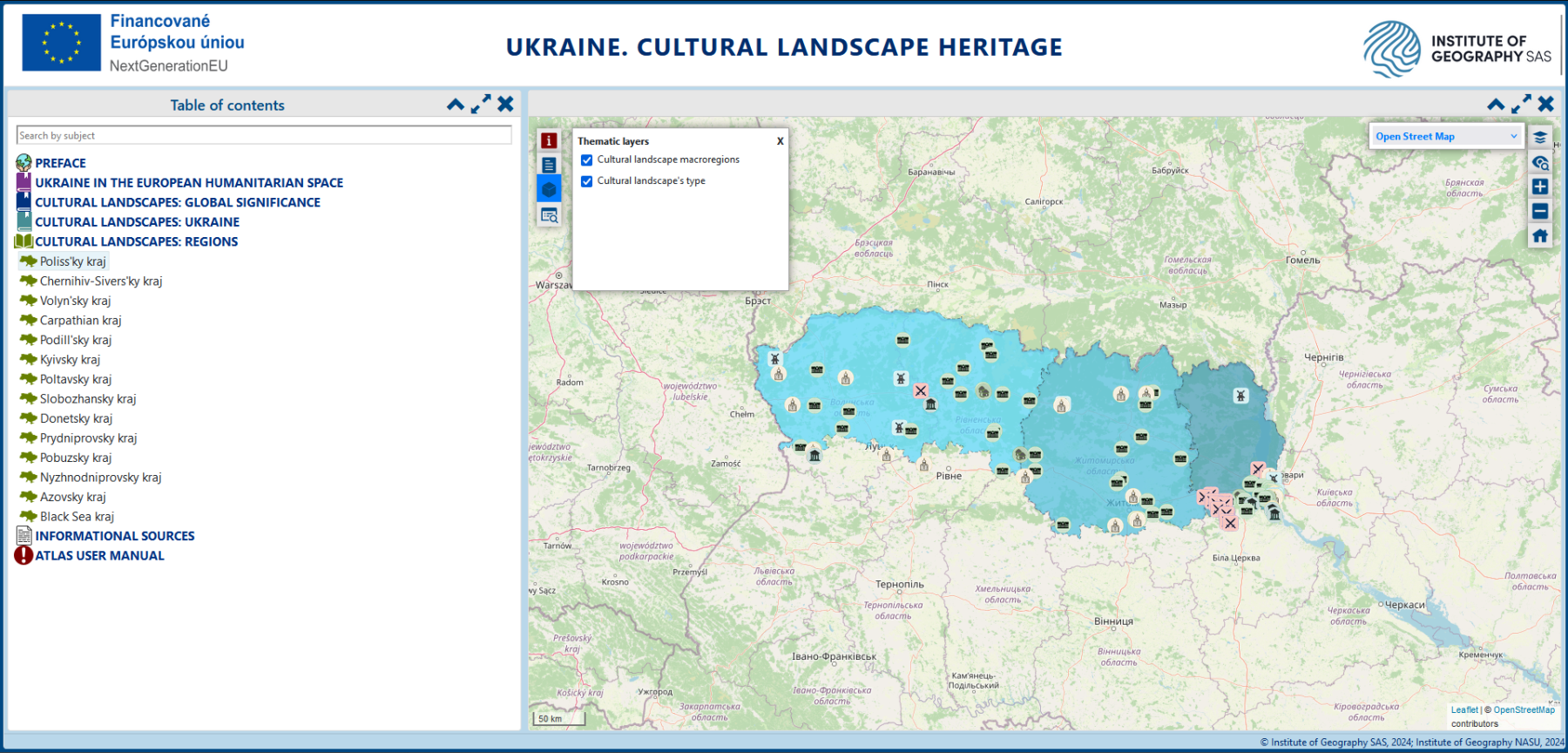
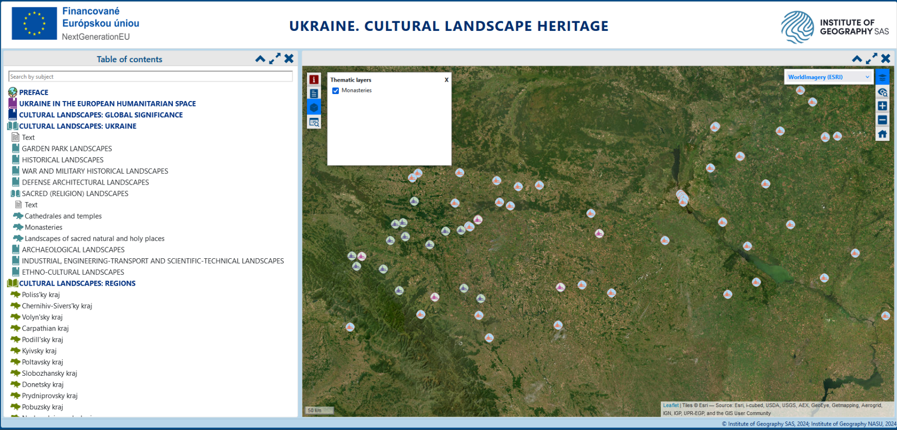
The interactive atlas contains 39 electronic maps. The structure of the Atlas uses a multi-level and comprehensive representation of phenomena and objects at the global, national, regional and local territorial levels. The content of the Atlas is divided into 4 main thematic sections and subsections of general, typological, and regional focus.
The section ‘Ukraine in the European Humanitarian Space‘ contains maps that characterise Ukraine’s place in terms of such basic features as its physiographic and political-geographical position in Europe, and its role in the European part of the UNESCO World Heritage List.
The section ‘Cultural Landscapes of Ukraine of World Importance‘ presents the outstanding cultural landscapes of Ukraine inscribed on the UNESCO World Heritage List and nominated for inscription in the category “cultural landscape”, also objects included in the lists of the most significant historical, cultural, and natural monuments based on the results of the all-Ukrainian public campaigns held in 2007-2020. The main subject of this section is the map “Cultural Landscape Zoning of Ukraine” (CLZ). Based on the results of the CLZ, 14 cultural landscape regions (kraj) and 52 cultural landscape macro-regions were identified.
The section ‘Cultural Landscapes: Ukraine‘ presents approximately 2,000 of the country’s most significant cultural landscapes, covering a wide range of themes and including 20 maps accompanied by explanatory text, geolocation data, attribution and reference information, photographs and illustrations based on numerous statistical, bibliographic and internet sources. The key element of the overall structure of the Atlas is the inventory layers of the maps, which represent cultural landscapes according to the developed typological classification, which consists of 30 types, grouped by theme into 8 groups and 18 subgroups.
The maps in the section ‘Cultural Landscapes: Regions’ aim to reflect the distribution of cultural landscapes by selected types at the regional level and are intended to characterise each of the 14 cultural landscapes regions (kraj) and their cultural macro-regions in general and to present them in all their diversity.
An important part of the Atlas is the textual part that precedes the map sections, and a reference system with explanations of the general use of the Atlas.
To implement the Atlas, the AtlasSF Atlas Solution Framework was used, consisting of 8 patterns and 1 framework, namely: ptnAtUserInterface – user interface pattern; ptnAtTreeSolution – content tree pattern; ptnAtMapComponent – map component pattern; ptnAtThematicMap – thematic map pattern; ptnAtDocTemplates – non-map content pattern (HTML documents, diagrams, photos, etc.); ptnAtBaseMap – base map pattern; ptnAtSearch – search pattern; ptnAtWorkSpace – workspace (view) pattern; frmAtArchitecture – Atlas architecture framework that unites all the above patterns.
As a result, the first national cartographic work on cultural landscape themes of this size, number of themes and content was developed, providing a spatial representation of the peculiarities of the cultural landscape heritage of Ukraine.
The information system developed for the Atlas has an open structure, allowing it to be supplemented with species and quantitative parameters as further research is carried out.
The dissemination and use of the Atlas will contribute to the further development of thematic mapping and atlas-based geographic information systems for the protection and preservation of cultural and natural heritage.
The study was conducted at the Institute of Geography of the Slovak Academy of Sciences and funded by the EU NextGenerationEU through the Slovak Recovery and Resilience Plan under Project No. 09I03-03-V01-00021. This article is one of the results of the grant No. 2/0043/23 “Identification of landscape diversity and its changes in Slovakia based on remote sensing data in the context of the European Green Deal” with the support of the Slovak Scientific Grant Agency VEGA.
Text: Kateryna Polyvach